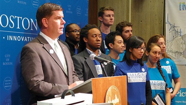
The team behind Imagine Boston 2030 issued a report last week that outlines the four goals that will guide its citywide planning. They are: “provide quality of life in accessible neighborhoods; drive inclusive economic growth; promote a healthy environment and adapt to climate change; and invest in infrastructure, open space and culture.”
Woven into all of these is the question of transportation. As the city considers how to further these goals, it will need to make important planning decisions around mobility. The report, “Guiding Growth: Towards an Inclusive City,” identifies the need to connect residents with locations of economic or educational opportunities, reduce greenhouse gas emissions and provide reliable transit to all neighborhoods.
“You can bring things closer to where people are living now, bring residential opportunities closer to where jobs and education opportunities are or make it easier to get there through infrastructure investments,” said Sara Myerson, executive director of Imagine Boston 2030.
Imagine Boston continues to gather resident feedback and assess needs and wants as it brings greater specificity to its vision. Future actions will involve identifying strategies and funding sources.
On the web
Guiding Growth report: http://imagine.boston.gov/wp-content/uploads/2016/03/Guiding-Growth-Towards-an-Inclusive-City.pdf
Boston’s cars
Currently, traffic in the city slows by an average of about 15 percent during peak times, according to a report by Go Boston 2030, a transit-focused planning initiative that is coordinating with Imagine Boston 2030. On highways such as I-93 and Route 1, morning commute slows by as much as 60 percent, the Go Boston report stated.
As Boston grows, managing traffic could become a major concern.
In April 2010, there were approximately 198,000 passenger vehicles registered in Boston, according to a Massachusetts Vehicle Census conducted by the Metropolitan Area Planning Council. This amounts to approximately 0.78 vehicles per household, MAPC Data Services Director Tim Reardon said.
At the same time that Boston’s population is growing, the average household size is declining, according to the Walsh administration’s “Housing a Changing City: Boston 2030” report. If the vehicle-to-household ratio remains constant, the effect on the roads could be significant. By 2030, the city is expected to have 20 percent more households, according to “Housing a Changing City.”
Demand for options
The growing population and household counts could portend a greater crush of cars on the road. But, some said, the city could head this off by facilitating alternative travel options.
“There is a lot of pent-up interest in biking or walking,” said Rafael Mares, vice president and director of Healthy Communities and Environmental Justice for the Conservation Law Foundation.
He said that young people have showed lower interest in driving, a trend that could be tapped into if opportunities are provided.
“Fewer and fewer young people are getting driver’s licenses,” he said.
“Driving is declining faster than Boston is growing,” Go Boston 2030’s latest report states, adding that individual driving rates dropped 10 percent in the last decade. Goals set forth by Go Boston call for increasing the number of commutes taken by public transit, bicycle and by foot, and halving the number of commuters who drive alone to work.
Low-car mentality
According to its “Guiding Growth” report, Imagine Boston 2030 is exploring strategies to “improve bike, pedestrian, bus and train mobility, better connect Boston’s neighborhoods and encourage Bostonians to take more trips on public transit.”
One way the city can work toward transit goals is by assuming in its development plans that people will be using diverse transportation methods — not just cars, Alice Brown, project manager for Go Boston 2030, said.
In part, this can mean building sufficient sidewalk space and timing crosswalk lights to allow frequent pedestrian movement. The city also can create protected bikeways and build off-road cycle paths.
Designing projects that presume people will get there by car often has the effect of making it so, Reardon said.
“If we’re building a new development predicated on people driving to it, then we’ll have more traffic,” he said.
Reardon pointed to a proposed construction at Tremont Crossing that would have an 800-car parking lot: “That’s the kind of land use that will generate a lot of traffic in the area. It’d be possible to put other land use there and create far less parking because it is one of most accessible areas in the city.”
In locations where public transit options are available nearby, developers could encourage people to use it by buliding less parking, he said.
“[Planning for 2030] is not just about how many people and how many households, but how we’re building for that,” he said.
Public transit
Although the city does not control the MBTA — and thus trains, buses and drivers — it does control the streets the buses go down, and can allot space on the roads and time traffic lights to improve their service. To promote public transit, the city can designate separate bus lanes or queuing boxes at intersections to allow buses to get ahead of the line, Reardon said. Other options include traffic signals that prioritize buses.
Speaking at an event last week announcing Imagine Boston’s goals, Mayor Martin Walsh said restoring late night services to the MBTA “will be vital to 2030,” and said now is a time to consider how to strengthen and increase ridership on the T.
Go Boston 2030 currently works closely with the MBTA, Brown said, and several MBTA members are on its team.
Interconnected neighborhoods
The Guiding Growth report also cited a need for better connecting neighborhoods. In many cases, Mares said, someone taking public transit has to go downtown and then back out in order to get to an adjacent neighborhood, and many low-income areas and communities of color lack sufficient transportation.
While the city has yet to make any concrete plans, Brown said, some ideas for better linking neighborhoods have been suggested or could be drawn from other cities.
Brown said she had heard a suggestion for introducing shuttles that would link areas of Roxbury and Jamaica Plain — for instance between destinations such as a grocery store and a library. Another idea: Features could be introduced to improve the experience of walking between neighborhoods. For instance, Brown said, PLAN Dot Ave tackles the stretch of Dorchester Avenue Corridor between Andrew and Broadway. While the path is only a mile long, it can feel like two or three to someone walking, because the area is industrial and not a welcoming atmosphere, she said. Inclusion of stores, benches, parks and other amenities along the way could change that tone she said. There are plans in place to change zoning so that it is easier to diversity land use and make it more engaging.
State Rep. Russell Holmes, co-chair of the Go Boston 2030 advisory committee, said his planning focus is on targeting existing “transit deserts” and resolving inequalities for the people who currently live in the city, before those predicted to move into the city over the next 14 years.
Go Boston 2030 is expected to release its recommendations this August, Holmes said. Imagine Boston 2030 is scheduled to begin drafting strategies in May.


