At Moakley Park, redesign aims to protect neighborhoods, engage community

As a low-lying coastal city, Boston is at heightened risk for coastal flooding. To examine the challenges and opportuning of coastal resilience efforts, the Banner is digging into three sites along the metro-Boston shoreline where flooding could pose high risks and solutions are being crafted to create new models for the future. Part 2 of the series examines Moakley Park in South Boston.
Joe Moakley Park in South Boston sits oceanside. Only a roadway and a stretch of sandy beach separate it from the crash of waves.
That landscape pairs harbor views with heightened concerns about flooding as sea levels rise and storm events become more intense because of climate change. For years, the fields at the 60-acre park have become muddy and waterlogged from rainfall and storm surge and its flat terrain leaves neighborhoods on the other side of the park at risk.
City efforts would transform the park to increase coastal resilience and improve the space for community members.
“Given that the water in there with those rising tides would just come right up over Moakley, we have the opportunity to close that flood pathway through making improvements to the park,” said Cathy Baker-Eclipse, director of the Parks and Recreation Department’s capital plan.
For nearby residents, that protection could be vital. A few years ago, during large storm events, some homes saw flooding in basements during storm events, said Lumina Mathurin, who lives near the park.
Mathurin has lived at the Anne M. Lynch Homes since the projects were integrated 30 years ago. Along with the Mary Ellen McCormack, it is one of two public housing developments that abut the park.
She said she hasn’t seen flooding impact the Anne M. Lynch Homes yet, but during major storm events sandbags and barriers are stacked as a precaution to keep water out.
Efforts to make Moakley Park more resilient from sea-level rise are expected to benefit not just the residents of South Boston but all of the city. During the busing era, racial clashes at adjacent Carson Beach made Blacks wary of using public recreational resources in Southie. The subsequent integration of the all-white public housing projects bordering Moakley Park has brought greater diversity to the most frequent users of the open space while drawing residents from other neighborhoods of the city as well.
Coastal resilience efforts at the park would block off predicted flood pathways into nearby communities, while also providing protection from other climate impacts, said Chris Reed, the founding director at Stoss Landscape Architecture, the firm that has been designing the Moakley project.
“It started as a coastal resilience project, but as we learned more of what was going on, it also became a stormwater mitigation and urban heat mitigation project,” he said. “We’re looking at climate adaptation through a number of different lenses.”
Mixing resilience into play space
The city intends to start permitting the first phase of work at Moakley Park later this spring and hopes to begin construction early next year. Under the plan, it would divide types of solutions in different parts of the park.
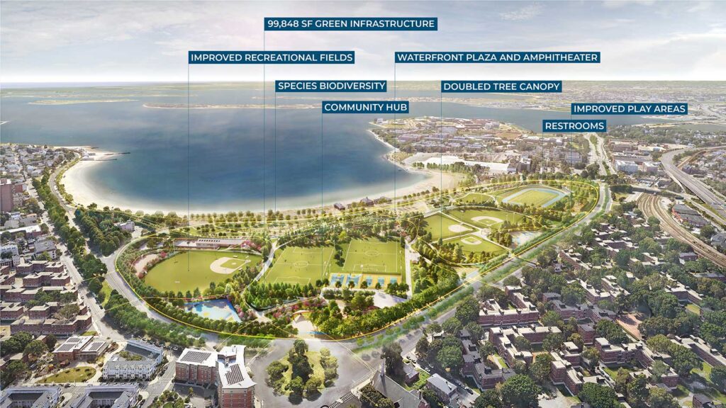
A strip along the eastern side of the park, its coastal edge, would be made into what Reed called a “coastal park,” designed to resemble New England shoreline environments. The structure and new landscaping would be intended to flood during storm surges.
“Floodwaters will come, floodwaters will recede, and that landscape will continue to function,” Reed said.
Also, part of that “coastal park” will be a topography of rising hills that rise up to add elevation to protect the landscape beyond
The rest of the park will also contain ways to trap water — what started as just an initiative to address coastal resilience also led to consideration of stormwater flooding, Reed said.
In some parts of the park, that will mean planting landscaped gardens where the soil and plants will absorb the water. In others, it’ll mean permeable pavement — alternatives to traditional concrete and asphalt that catch and collect rainfall — that will feed into an underground storage system and can later be used for irrigation.
Those permeable spaces will be built into efforts to make the park more attractive and engaging. Reed said the plan will include playground space and sports fields that will collect rainfall while also trying to attract residents from nearby neighborhoods.
As one of the biggest city-owned spaces along the shoreline, Reed said Moakley Park presents an opportunity to try out new techniques and landscapes like the floodable coastal park that he hopes will attract visitors and improve resilience.
Resilience work in parks also presents a unique opportunity to fuse coastal resilience efforts with community spaces, making the initiatives more approachable to communities.
“We can showcase that these spaces don’t have to be armored defenses, they can be spaces that function 364 days of the year as open space for people to use and enjoy and observe the world around them,” Baker-Eclipse said. “Those nature-based solutions are really as resilient as a defensive wall could be and allow a lot more flexibility.”
Boston landscapes present built-in challenges
Boston’s legacy as a coastal city has crafted geotechnical challenges that can complicate work like that at Moakley Park.
Old maps of the city from the 1600s and 1700s show a small chunk of land connected by a narrow spit — where Washington Street in downtown Boston runs today — connecting it to the land that makes up Roxbury and Dorchester.
At the time, Beacon Hill still stood in the old Boston, as did what is now the North End and the Boston Common, but chunks of the financial district and today’s Chinatown were then nothing but wetland. Back Bay from the Public Garden past Massachusetts Avenue and what is today South Bay were, as their names implied, marshy bays.
Over the years, as the city’s population expanded, work was completed to expand its physical footprint as well. Land on the outskirts of Boston, often then wetlands, was filled with earth taken from Beacon Hill and other hills.
That geological legacy complicates resilience efforts at Moakley Park. In the space that is now Moakley Park, once salt marsh and mudflats, the fill that was used is still settling. New berms and construction on top will only add more weight that pushes the fill down more. Add to that a system of old underground infrastructure that runs beneath the park.
“We’ve got the need to go up; we’ve got land that’s settling; we’ve got this technical challenge of not wanting to load on top of old infrastructure but the need to do it in some ways,” Reed said. “With the technical team on this we’re getting our money’s worth out of it.”
Baker-Eclipse, with the caveat that she is not an engineer, described trying to build a berm on filled land like trying to build on pudding.
Landscape architects and engineers have a handful of solutions that can be used to build up without pushing down too much. In much of Boston, structures have been built on long wooden pilings — telephone pole-like installations that go down to more stable layers underground to keep pressure off the settling fill.
Lightweight fill materials are often a solution. For example, at Martins Park in Seaport, resilience efforts used geofoam, a lightweight material made out of expanded polystyrene — like an architectural cousin of styrofoam — to raise the grade of the land at the park by 10 feet.
“If you were to just place some regular old soil, all of those nice new playground finishes would have settled relatively quickly and become damaged,” said Jonathan Patch, an engineer with McPhail Associates who worked on efforts at Martins Park in Seaport.
Reed said a mixture of solutions will be used in the work at Moakley Park, based on what areas can take more or less load.
Mixed jurisdictions around Moakley Park
The project at Moakley Park presents a mix of challenges and benefits around collaboration with other levels of government. The park itself is all under the purview of the city’s Parks and Recreation Department, but infrastructure buried beneath the park belongs to a number of city and state bodies.
For Mathurin, as she visited the park and tried with other community members to keep it as well maintained as she could, finding the right person to talk to about an issue was often challenging. Leading community members to often feel as if they needed to tackle challenges with things like general park cleanliness by themselves.
“It was like a fight trying to figure out 211, 311, 411 — who was responsible and who would fix this park? Who does this part belong to?” she said.
Similar challenges are present in work around resilience. Day Boulevard and Carson Beach, the only things separating Moakley Park from the harbor, are owned by the state’s Department of Conservation and Recreation. State-owned land just north and south of the park also present opening for flooding into neighborhoods.
“We, pretty early on in the design process, recognized Moakley Park was probably the biggest missing link, but it wasn’t the only missing link,” Baker-Eclipse said.
It’s a challenge facing parks, neighborhoods and roads throughout the city’s coastline.
But state partnership has also allowed for specific support. In 2019, the Moakley Park project received $1.5 million from the state as part of the Office of Coastal Zone Management’s Municipal Vulnerability Preparedness program for design, technical analysis and assessment.
The city of Boston also received funding through the program in 2018 to support development of zoning and design guidelines around coastal flood resilience. In 2021, the city also received program funding for a a heat resilience study.
But the landscape at Moakley Park is also unique in the large scale of land the city does own. Reed said that opportunity — with 60 acres of city-owned land on the shore front — presents an opportunity for the city to show some of what is possible in coastal resilience work.
“This is one of the biggest contiguous pieces of property the city controls and [city offials] can use the project as a demonstration of how you do integrated infrastructure to combat coastal flooding,” Reed said. “We are still dealing with a number of other city and state agencies that have utilities underneath, but the city controls the land, so that means there can be a fairly coordinated system put in place to do it.”
Want to read more? Check out Part 1, looking at Dorchester’s Tenean Beach, here


